How Al Qaeda are bringing a little retro-chic to the dapper sailor-about-harbour’s must-have navigation aids.
 It might surprise the young whippersnappers of the nautical world, but satellite navigation isn’t quite the revolution you might think it is. It’s merely an evolution of electronic position fixing technology that has been around for the best part of a century.
Truth is your father, where he a sailor, had access to electronic position fixing, and so did his father, and probably his father too.
Of course though, at least by today’s standards, it was shit.
Who’s the daddy?
The undisputed heavyweight of yesterday’s electronic position fixing was LORAN (Long Range Navigation), a rather clever hyperbolic navigation system which relies on the time-differences between radio signals to work out which of a set of position lines you must be on. And as every good navigator knows, if you can get two position lines at the same time, say from two pairs of transmitters, then where they cross is roughly where you are.
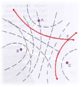 Early equipment would simply identify the position line for you. Navigational charts overprinted with the local Loran lattice showed where each position line was and thus let you identify your location.
As technology improved Loran receivers were soon able to do the heavy lifting for you and read out a latitude and longitude, though old-school Loran lattice charts where still being printed until just a few years ago.
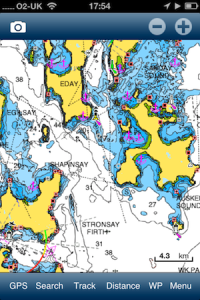
Compared to modern, full-colour, big-screen, GPS integrated chart plotters with that comforting little boat icon planted square where you happen to be this, of course, all sounds rather hateful.
But it worked. It worked during World War II and it worked for generations of coastal and ocean mariners since.
And it still works. And it turns out, when compared to GPS, in some ways it works quite a bit better.
Satnav Jihad
The end of Selective Availability in May 2000 and the technological leaps and bounds since have made GPS pretty much ubiquitous. In your car, in your boat, in your phone – it seems anything that could possibly benefit from knowing its exact position on the face of the earth can now do so.
But satnav’s hegemony might not be all that it seems. Enter stage left another aspect of the geo-political harmony of our age of enlightenment. Terrorism. The more our way of life is dependent on something, the more interesting it is to those who would choose to destroy that way of life. And satellite navigation, it turns out, offers rather easy pickings.
Electronic insurgency
Satellites, you see, are rather a long way away. And as every good schoolboy knows, radio waves tend to diminish in strength with distance. Now taking out a navigational satellite may well be beyond the means of (most) terrorists, but making mischief at the receiving end is a different matter entirely.
From delivery drivers with $50 GPS jammers on their dashboard to North Korea’s truck-sized devices occasionally disrupting the South’s aviation and shipping, a recent article in The Economist highlighted the ease with which satellite navigation can be rendered next to useless on a fairly large (albeit local) scale.
Loran transmitters, on the other hand, aren’t such a long way away. And that means Loran might not be getting the early retirement it was perhaps hoping for.
Every time I think I’m out, they pull me back in
Don’t rush off panic-buying those out-of-print Loran Lattice Charts at the local boat jumble just yet though. For a start, eLoran (presumably Steve Jobs had nabbed iLoran) is where it’s going to be at. The next generation of Loran technology is already live around part of the UK with full commercial coverage just a few years away.
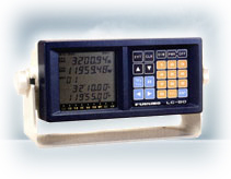 Secondly modern Loran receivers support NMEA so can feed the position right into your chart plotter just like your GPS does. No need to transfer a position from a digital read-out nor dust off the pencils and unfold that lattice chart.
Thirdly, compared to GPS receivers, Loran receivers are, er, kinda pricey. Think a couple of grand as opposed to a couple of hundred. Aside from commercial shipping, squarely one for the die-hard gadget heads.
And as for Captain Ben, well, I’m not worried anyway. I rather like being lost.